The soils beneath Douglas Island and the Mendenhall Valley tell two completely different stories. On Douglas, you hit weathered bedrock and granular tailings within a few feet. Out in the Valley, glacial rebound has left deep sequences of silt, organic layers, and outwash sand that shift classification from one lot to the next. A single field log can't resolve that contrast: you need the full particle-size curve from coarse gravel down to clay fraction. Our grain size analysis combines mechanical sieving through the No. 200 sieve with ASTM D422 hydrometer sedimentation, producing a continuous gradation that feeds directly into USCS classification under ASTM D2487. For projects near Gastineau Channel, we also look for the transition zone where marine clay fines influence drainage behavior, because that's where most foundation surprises in Juneau start.
A clean-looking sand with 12% non-plastic silt fails drainage criteria that a 4% silt sand passes. The difference only shows up on a full wash-sieve curve.
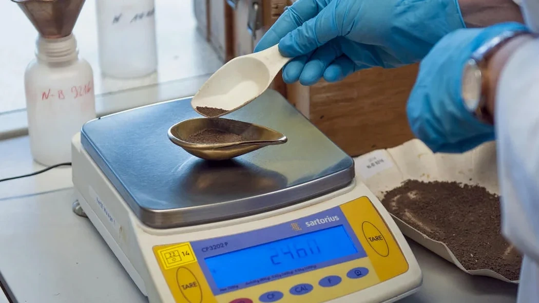
How we work
The most expensive mistake we see in Juneau is classifying a silty sand as clean sand based on a quick field shake test, then designing a footing drain that clogs within two seasons. Southeast Alaska's glacial deposits contain just enough non-plastic silt to plug a standard filter fabric, but not enough to look problematic in a hand-auger sample. Our lab procedure eliminates that guesswork. We oven-dry the specimen, run it through a stack of sieves from 3-inch down to No. 200, then take the minus-200 fraction into a hydrometer cylinder with sodium hexametaphosphate dispersant. Temperature-corrected readings at 15, 30, 60 seconds and onward give the silt-clay split. The result is a single semi-log curve showing D10, D30, D60, and the full shape of the distribution. For Valley sites with high groundwater, we often pair this data with an
Atterberg limits run on the same sample to confirm whether the fines are plastic clay or inert rock flour, and for deep infrastructure we tie gradation to
SPT drilling logs to correlate blow counts with soil type at depth.
Site-specific factors
Juneau's rainfall exceeds 90 inches annually, and that number drives everything about gradation interpretation. A poorly graded sand that drains freely in Phoenix will trap perched water here once glacial silt migrates into the pore spaces over a few wet seasons. The risk compounds on slopes above the Lemon Creek and Mendenhall River corridors, where fine-grained colluvium overlies dense till. Without a hydrometer curve, you might misread the silt content and under-design subdrain capacity, leading to pore pressure buildup during October storms. Even in flatter areas like the airport industrial zone, fill placed decades ago often contains interbedded layers of crushed rock and silty dredge spoils from the channel. A composite sieve-and-hydrometer analysis on each distinct layer identifies which zones will transmit water and which will hold it, letting you size drainage and select filter gradation correctly before excavation starts.
Quick answers
What does grain size analysis cost for a Juneau project?
A standard sieve-plus-hydrometer package runs US$110 to US$170 per sample, depending on whether we run the full hydrometer sedimentation or a shorter silt-clay split. Volume pricing applies for multi-sample projects like road borrow evaluation.
How long does the hydrometer portion take?
The hydrometer sedimentation reading runs over roughly 24 hours for the clay fraction to settle, plus temperature correction and calculation time. Combined with the sieve portion, we typically deliver the full report in three to four working days from sample drop-off.
Do you need a hydrometer test if the soil looks clean and sandy?
In Juneau, yes. Glacial sands here often carry 8 to 15 percent non-plastic silt that does not show up in a simple wash-through-200 without dispersion. That silt fraction changes the permeability by an order of magnitude and affects filter design, frost susceptibility, and seismic liquefaction assessment under ASCE 7 criteria.